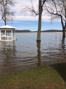
Flooding
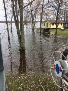
When water enters a watershed too quickly for the land to absorb it, flooding can occur. Floods result from the rapid melting of winter snows, severe thunderstorms, tropical storms and other high rain events. On developed land with lots of impermeable surfaces such as pavement and roofs, water flows off more quickly compared to forested and grassy areas. This causes water levels in lakes and streams to rise rapidly and leads to flooding conditions. In addition, as water runs over and through the landscape, it picks up and carries pollutants and sediments to waterbodies, where it affects the quality of the water.
Floods are the most frequent and costly natural hazards in New York State in terms of human hardship and economic loss, particularly to communities that lie within flood prone areas or floodplains of a major waterbody.
Some waterbodies prone to flooding include:
- Seneca River and Cross Lake
- Cayuga and Owasco Lakes lakeshore properties
- Lake Ontario shoreline, including Little Sodus Bay
- Owasco Inlet and its tributaries in Moravia and Locke
- Owasco River in the Port Byron area, particularly during the winter
Floodplain maps can be found on the Federal Emergency Management Agency website. The flyer “Managing the Water Resources of the Oswego River Basin in Central New York” can be found at https://pubs.usgs.gov/fs/1999/0180/report.pdf.
Unfortunately, over the years development has occurred in floodplain areas. Homes in floodplain areas often face substantial damage during times of flood. Currently there are regulations that must be met before building within these areas. Property owners should check with local building officials prior to disturbing areas within a floodplain.
Lake Levels
The lake levels of Owasco Lake, Cayuga Lake, Skaneateles Lake and Cross Lake are controlled by dams. Dams impacting Cayuga and Cross lake levels are maintained by the New York State Canal Corporation, the dam impacting Owasco Lake is maintained by the City of Auburn, and the dam impacting Skaneateles Lake is maintained by the City of Syracuse. Information regarding the purposes of lake level regulation and lake level targets (also known as Rule Curves) can be found on the New York State Canal Corporation website.
View current and historical lake levels for Owasco Lake (Datum of gage is NGVD of 1929)
View current and historical lake levels for Cayuga Lake (Datum of gage is NGVD of 1929)
View the current lake level for Skaneateles Lake (Datum of Gage is Syracuse Datum which is 1.75 ft. below NGVD of 1929)
There is not a functioning gauge to measure the lake level at Cross Lake. View the level of the Seneca River upstream of Cross Lake near Port Byron (Datum of gage is 300.00 ft above NAVD of 1988), and downstream of Cross Lake near Baldwinsville (Datum of gage is 299.05 ft above NAVD of 1988).
Information on the level of these two locations, as well as others, can also be obtained by calling the New York State Canal Corporation at 315-423-2094. Please note that the elevations reported by the Canal Corporation are based upon Barge Canal datum, which is different than what is reported by USGS sites above.