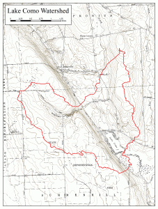
Lake Como is a small, relatively shallow lake in the Town of Summerhill, located in the Oswego-Seneca-Oneida River Basin, south of the Seneca River. It is an upland lake, formed in the upper portions of the Cayuga Lake Fall Creek sub-Watershed. It is part of an extensive wetland system. Two unnamed tributaries (rivers or streams flowing into a larger river or lake) enter Lake Como in the north and the water flows from the lake via the Lake Como Outlet in the south.

Lake Como Physical Features
Elevation: 1309 feet
Area: 0.11 square miles
Shoreline Length: 1.7 miles
Length: 0.6 miles
Maximum Depth: 20 feet
Mean Depth: 10 feet
Towns adjacent to the Lake: Summerhill
Lake Como Watershed Features
Area: 4.4 square miles
Counties: Cayuga
Towns within the watershed: Summerhill, Sempronius, and Locke
Villages within the watershed: None
Lake Como Watershed Plans and Guiding Documents
The Lake Como State of the Lake and Watershed Management Plan was developed in 2007.
Groups involved with protecting Lake Como
Lake Como Association: contact Pjmooney47@yahoo.com for more information.
Lake Como Data
Lake Como Aquatic Vegetation Comprehensive Survey Report July 2024 is available for review.
Research and Data on Cross Lake
Citizens Statewide Lake Assessment Program (CSLAP) Reports
CSLAP reports are created from data collected by sampling volunteers from member lake associations. Reports from 2019-present are available here. Reports from 1997 through 2020 can be found on the NYS Federation of Lake Associations (NYSFOLA) website here.
Data and information can be found on the NYSDEC’s Division of Water Monitoring Data Portal. Go to the portal and search for Lake Como.
Additional Resources
New York State Department of Environmental Conservation Lake Como Webpage

